River Floodplain Condition Report 2021 Shows Urgent Need for Action on River Floodplains in Germany
The Geoinformation Management course at Karlsruhe University of Applied Sciences is providing scientific data for the Federal Environment Ministry's 2021 floodplain condition report via the three-year research project "River Floodplain Balancing and Assessment 2.0"
March 25, 2021
The 2021 floodplain condition report presented today (Thursday) by Federal Environment Minister Svenja Schulze and the President of the Federal Agency for Nature Conservation, Prof. Dr. Beate Jessel, is based on the three-year research project "River Floodplain Balancing and Assessment 2.0," which was conducted under the project management of Prof. Dr. Detlef Günther-Diringer, Dean of the Bachelor's degree program in Geoinformation Management at Karlsruhe University of Applied Sciences, in cooperation with the Ing. Office Koenzen (Hilden) in the last three years has been carried out.
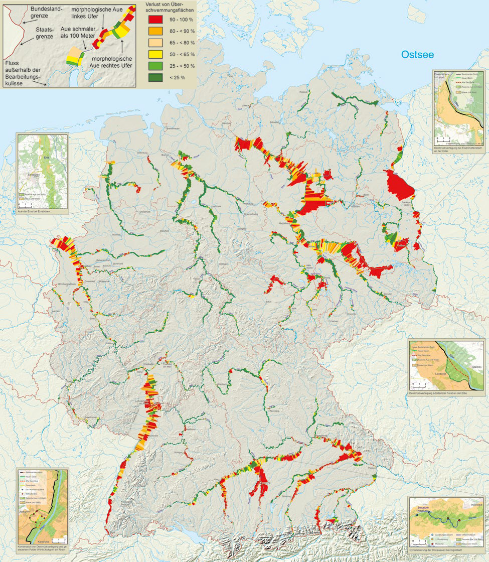
There is still an urgent need for action regarding the condition of floodplains in Germany: although the floodplain condition has not seriously deteriorated in the last ten years, more than half of the floodplains in Germany have been severely altered by river straightening, dike construction and intensive land use. Two thirds of the riverine floodplains are not available as floodplains during floods. The second floodplain condition report since 2009 documents the condition of Germany's river floodplains, the loss of floodplains and the status of floodplain restoration. The Floodplain Status Report is a valuable source of information and a basis for decision-making to advance floodplain protection at the federal and state levels.
Research to determine floodplain condition
Using current geoinformation technology, Karlsruhe University of Applied Sciences was able to compile and analyze extensive and detailed geodata nationwide. Floodplain areas along more than 10,000 km of rivers were documented and balanced based on flood modeling, land use data, and protected area information. Based on this, the ecological assessment of the floodplain condition was carried out in an assessment procedure developed by Büro Koenzen. "Through the project carried out at Karlsruhe University of Applied Sciences, many students in the geoinformation management course were able to gain insight into realistic geo projects. Methods for individual building blocks of the project could be developed in the form of student research projects and theses," explains Prof. Dr. Detlef Günther-Diringer.
The large, current demand for environmental applications in the geoinformation sector has led to further development of the course, which will start in the winter semester of 2021/22 under the name "Environmental and Geoinformation Management" at Karlsruhe University of Applied Sciences.
Further information
The floodplain condition map and loss map developed at the university are available on the pages of the BfN